CONTINENTAL DRIFT AND PLATE TECTONICS
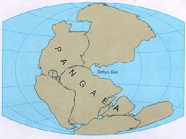
The diagram to the
left shows a map fit of the continental masses about 150-200 years ago--this is
a piece of data used to confirm that the continents drifted to where they are
today-- the concept of continental drift initiated the rock plate concept
I. Continental drift concept
A. Introduction and early concepts
1. Introduction
·
the big
question is "did the continents originate at their present locations or
did they drift to where they are today?"---even
with much data indicating the continents drifted there are those who refute the
continental drift idea--we will treat some data supporting the drift idea in
I.B. in the outline below. With this chapter, the amount of data needed to
support a theory will be displayed.
·
a solid lithosphere floating on top of the asthenosphere
gives an idea how plates can move
·
Accretion of continental material is also an important
during continental drift to help shape the continents today— see
page 428 in text
·
formulation of the drift concept supplied much information
to the rock plate and plate tectonic concept
·
our earlier studies on the Earth's interior structure should
give us a better understanding of how the lithosphere is able to drift (solid
upper Earth floating on the asthenosphere)
2. Initial
ideas of continental drift
·
the most
obvious feature which would lead someone to believe the continents drifted
apart is the jig saw puzzle or map fit of continents. Looking at a global map
it would appear that the continents could be brought together to fit like a jig
saw puzzle--this would seem to imply that the continents must have been
together at one time and drifted apart
·
click here to see the map fit of
land masses or pictures
on page 385 in text
·
who was the first to see the map fit phenomenon?---Alfred
Wegener was the first to publish a summary of the ideas of the continental
drift concept in 1912 and for this was given the title of "The Father of
Continental Drift"
·
some facts noted in the Wegener's publication were:
o
the (protocontinent) was named
Pangaea
o
the southern portion was named Gondwana
(Gondwanaland) and the northern portion, Laurasia
o
the protocontinent broke in pieces
about 150-200 million years ago
B. Some important data confirming continental drift
1. Map fit (jig saw puzzle
effect)--mentioned earlier
2. Mountain chains formed with longitudinal
axes perpendicular to the movement of continents at subductive
plate boundaries
·
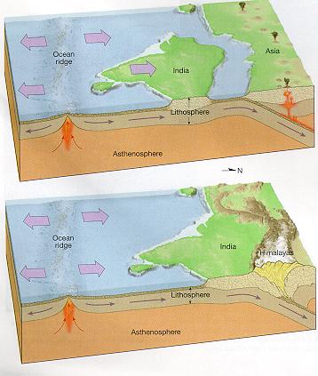
an example is the formation of the Himalayan Mountains--the
trend of the axis is east-west and formed from the Indian subcontinent moving
northward buckling up material while colliding with the Asian continent--
another example is the Rocky and Andes mountain chains (axes trending mostly
N-S) formed in part from the western movement of the North and South American
continents
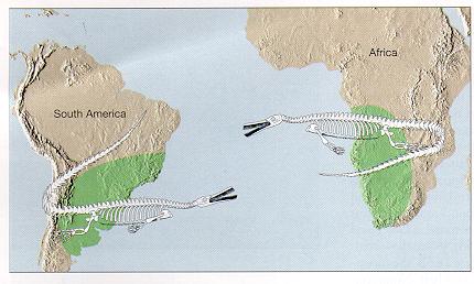
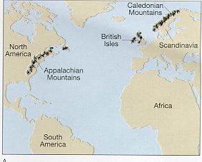
3. Same fossils, rocks, mountain
ranges, or glacial features located in areas on different continents
representing prejoined positions prior to continental
drift
·
click here to see matching
fossils or page 364
in text
·
click here to see matching
mountain ranges or page 365
in text
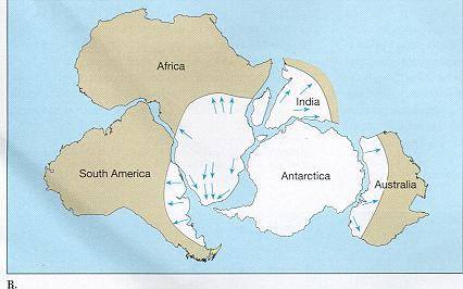
·
click here to see matching
continental ice deposits or page
366 in text
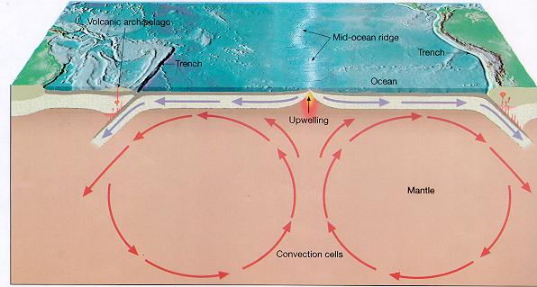
4. The presence and shape of the
global ocean ridge
·
the global ocean ridge is a raised region on the ocean basin
which is believe to represent the prejoined or
splitting area of separated continents--note the shape of the ridge contours
the shape of the coast lines of the separated continents--this is most evident
in the mid Atlantic ocean
·
convection cells in the Earth's interior are the force which
split the lithosphere and are the driving force in continental separation
·
click here to see a pair of
convection cells or see pages
386-387 in text
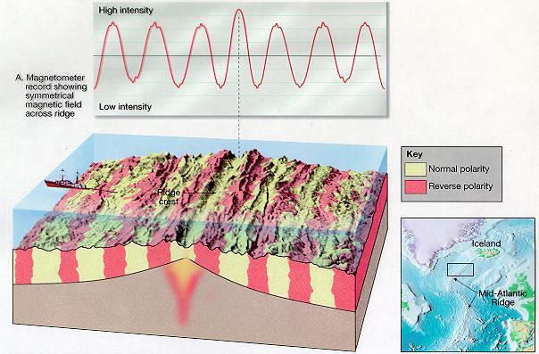
5. Seafloor spreading
·
the age of rocks located the same distance away from the
center of the ridge on both sides of the ocean ridge are the same--rocks are
youngest nearest the ridge center and progressively older away from the
center--this indicates new rocks form at the ridge centers and older rocks are
pushed away to make room for younger rocks resulting in spreading of the ocean
floor and continental drifting
·
also the magnetic intensities in the rocks are found to be
the same on equivalent sides of the ocean ridge--on both sides of the ridge the
magnetic intensity alternates between normal (high intensity) and abnormal (low
intensity)
·
click here to see magnetic
intensities across the ocean ridge or
see pages 383-384 in text
click
here for more information treated above and material below
CLICK HERE TO SEE
ANIMATIONS OF CONTINENTAL DRIFT PAST AND FUTURE
II. Lithospheric plates and plate
tectonics
- if the ocean floor is spreading
from ocean ridges and continents are drifting, where are the spreading
sections going?-- the answer to this question was
important in initiating the concept of rock plates--the question was
answered with the discovery of subduction zones in the lithosphere--rock
sections moving away from spreading zones are moving towards subduction
zones---see page 389 (Did you
Know?) to show
the repetitive periods of continental drift.
A. Rock plates
- ocean basin and
continental sections float in the asthenosphere, some plates move towards
each other, some away from each other, and some parallel to each other
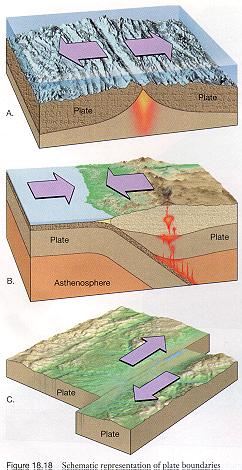
B. Classification of plate
boundaries
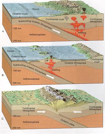
- click
here to see the 3 types of plate boundaries, divergent (A), convergent
(B), and transform (C) or see page 371 bottom of picture in text
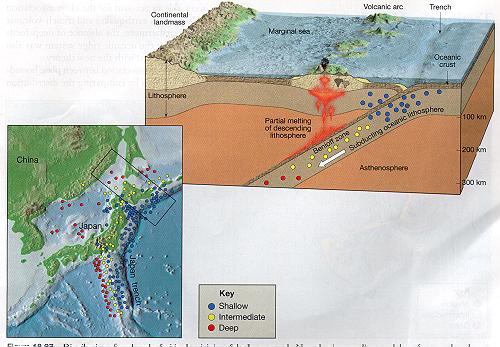
- volcanism and seismic
activity are concentrated at plate boundaries
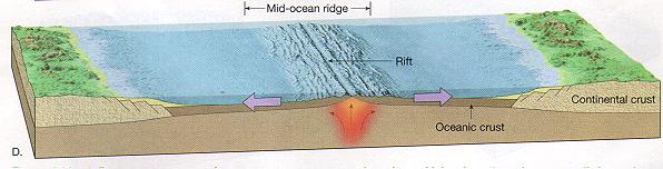
1. Divergent – see
page 372 in text for formation of a divergent boundary
·
includes all ridges and rifts
·
tensional forces caused by convection cells drive plates
apart
·
kinds of divergent boundaries
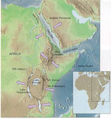
o includes ocean basin to ocean basin boundary or continental to continental boundary--examples are the mid-ocean ridge and African Rift Valley respectively--click here to see ocean basin to ocean basin boundary and click here to see continental to continental boundary
·
includes all
subduction boundaries
·
compressional
forces caused by convection cells are active to drive plates towards each other
·
volcanic arcs
are associated with convergent boundaries
·
kinds of
convergent boundaries
o
click here to see the 3 types of convergent boundaries
·
click here to see the transform fault
boundary off the coast of California
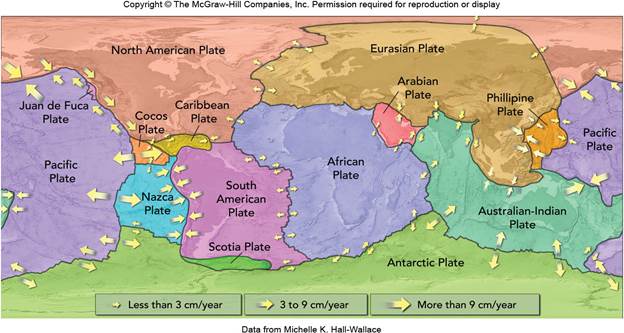
C. Map of Major plates on Earth or see pages 370-371
in text